Google Maps is known for being one of the most useful mapping applications out there. It is simple to use and it comes with features like satellite view. There are lots of personalizing directions as well and users can create, save, and edit maps with only their Google account. See How To Create A map in Google Maps using My Maps?
How Can I Create A Map In Google Maps?
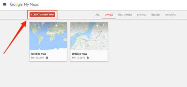
- Get yourself signed in to My Maps with your Google account.
- Tap “Create A New Map.”
You Might Also Want To Read- How To Report Road Incidents In Google Maps On Your iPhone?
- You will be shown a photo of the present continent or nation you live in and a search bar.
- Enter a city or even a precise landmark in the search bar at the top.
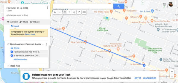
- Tap “Add Directions” (It is a little box with a curving arrow on it.)

- The Google Maps sidebar will now be visible with 2 search bars.
- Enter your starting point in the top search bar and your destination in the 2nd one.
- Tap “Untitled Map” at the top of the sidebar. This will reveal a fresh pop-up prompting you to type in the title of your map.
- As soon as you tap Save, your fresh map will be stored in My Maps on your Google account.
How Can I Open A Map In Google Maps?
- Get yourself signed into My Maps.
- You will see your maps in the “My Maps” dashboard.
- Tap on the map you wish to open. You will now be able to access and edit it.
How Can I Edit A Map In Google Maps?
- Get yourself signed into My Maps.
- Access the map you wish to edit.
- On the left sidebar, you will be able to make various edits, like adding layers or personalizing the look.
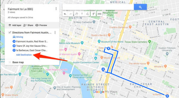
- Tap “Add Destination” to include a stop.
You Might Also Want To Read: How To Avoid Highways On Google Maps?
- You can reorder the stops by grabbing the letter on the left of the destination you wish to move.
- Drag the destination to the spot where you need it to be.
More Information About Google Maps
Google Maps is a web mapping service developed by Google. It offers satellite imagery, aerial photography, street maps, 360° panoramic views of streets (Street View), real-time traffic conditions, and route planning for traveling by foot, car, bicycle and air (in beta), or public transportation.
Google Maps began as a C++ desktop program at Where 2 Technologies. In October 2004, the company was acquired by Google, which converted it into a web application. After additional acquisitions of a geospatial data visualization company and a realtime traffic analyzer, Google Maps was launched in February 2005. The service’s front end utilizes JavaScript, XML, and Ajax. Google Maps offers an API that allows maps to be embedded on third-party websites, and offers a locator for businesses and other organizations in numerous countries around the world. Google Map Maker allowed users to collaboratively expand and update the service’s mapping worldwide but was discontinued from March 2017. However, crowdsourced contributions to Google Maps were not discontinued as the company announced those features will be transferred to the Google Local Guides program.
Google Maps’ satellite view is a “top-down” or “birds eye” view; most of the high-resolution imagery of cities is aerial photography taken from aircraft flying at 800 to 1,500 feet (240 to 460 m), while most other imagery is from satellites. Much of the available satellite imagery is no more than three years old and is updated on a regular basis. Google Maps used a variant of the Mercator projection, and therefore could not accurately show areas around the poles. However, in August 2018, the desktop version of Google Maps was updated to show a 3D globe as the default projection. It is still possible to switch back to the Mercator Projection in the settings.
Google Maps for Android and iOS devices was released in September 2008 and features GPS turn-by-turn navigation along with dedicated parking assistance features. In August 2013, it was determined to be the world’s most popular app for smartphones, with over 54% of global smartphone owners using it at least once.
In 2012, Google reported having over 7,100 employees and contractors directly working in mapping.