Google Earth is a brilliant tool. It lets users explore far-off and unfamiliar locations, to view what they appear like in 2D or 3D, and even dig deep into local points of interest. By default, things would be visible as they appear now.
However, because of the program’s historical imagery tool, what the map would’ve appeared like at different points in time would be seen as well, even if this feature does not work for all locations. Let’s show you How To Go “Back In Time” In Google Earth?:
How Can I Go Back In Time On Google Earth?
Before you begin, bear in mind that for you to check out a map over time, you will need to use the downloadable app version of Google Earth, instead of the mobile application.
- Head to https://www.google.com/earth/versions/#download-pro to get Google Earth Pro downloaded. Get it installed on your PC, and then launch it.
- Tap the search bar at the top of the left sidebar and look for the location you wish to see. It could be a city and state or nation, GPS coordinates, a street name, a particular address, ZIP or postal code, or a general place.
- Tap “Search.”
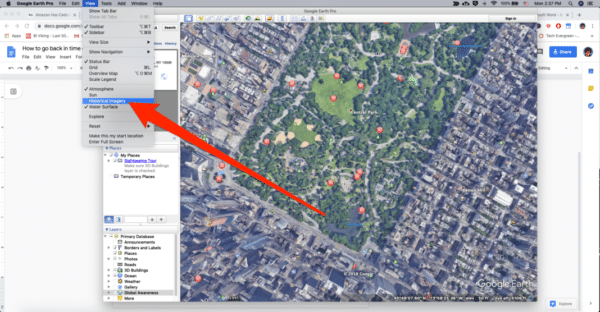
- Tap “View” in the menu bar at the top of your display, and then “Historical Imagery.”
You Might Also Want To Read- How You Can Make John Legend Your New Google Assistant Voice?
- A bar will open up at the top of your 3D viewer that will allow you to swipe back in time. The map will change as you swipe through time.
And you are done.
More Information About Google Earth:
Google Earth is a computer program that renders a 3D representation of Earth-based primarily on satellite imagery. The program maps the Earth by superimposing satellite images, aerial photography, and GIS data onto a 3D globe, allowing users to see cities and landscapes from various angles. Users can explore the globe by entering addresses and coordinates, or by using a keyboard or mouse. The program can also be downloaded on a smartphone or tablet, using a touch screen or stylus to navigate. Users may use the program to add their own data using Keyhole Markup Language and upload them through various sources, such as forums or blogs. Google Earth is able to show various kinds of images overlaid on the surface of the earth and is also a Web Map Service client.
In addition to Earth navigation, Google Earth provides a series of other tools through the desktop application. Additional globes for the Moon and Mars are available, as well as a tool for viewing the night sky. A flight simulator game is also included. Other features allow users to view photos from various places uploaded to Panoramio, information provided by Wikipedia on some locations, and Street View imagery. The web-based version of Google Earth also includes Voyager, a feature that periodically adds in-program tours, often presented by scientists and documentarians.
Google Earth has been viewed by some as a threat to privacy and national security, leading to the program being banned in multiple countries. Some countries have requested that certain areas be obscured in Google’s satellite images, usually areas containing military facilities.
The core technology behind Google Earth was originally developed at Intrinsic Graphics in the late 1990s. At the time, the company was developing 3D gaming software libraries. As a demo of their 3D software, they created a spinning globe that could be zoomed into, similar to the Powers of Ten film. The demo was popular, but the board of Intrinsic wanted to remain focused on gaming, so in 1999, they created Keyhole, Inc., headed by John Hanke. Keyhole then developed a way to stream large databases of mapping data over the internet to client software, a key part of the technology, and acquired patchworks of mapping data from governments and other sources. The product, called “Keyhole EarthViewer”, was sold on CDs for use in fields such as real estate, urban planning, defense, and intelligence; users paid a yearly fee for the service. Despite making a number of capital deals with Nvidia and Sony, the small company was struggling to make payroll, and employees were leaving.
Google Earth has numerous features that allow the user to learn about specific places. These are called “layers”, and include different forms of media, including photo and video. Some layers include tours, which guide the user between specific places in a set order. Layers are created using the Keyhole Markup Language, or KML, which users can also use to create customized layers. Locations can be marked with placemarks and organized in folders; For example, a user can use placemarks to list interesting landmarks around the globe, then provide a description with photos and videos, which can be viewed by clicking on the placemarks while viewing the new layer in the application.
Google Earth includes multiple features that allow the user to monitor current events. In 2007, Google began offering users the ability to monitor traffic data provided by Google Traffic in real time, based on information crowdsourced from the GPS-identified locations of cell phone users.